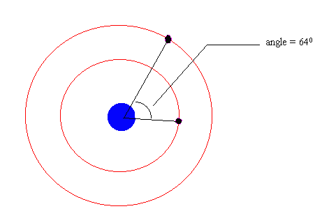
To determine the angle, first remember that the GPS satellite will be launched into an elliptical orbit with the point at which it reaches the desired circular orbit (this farthest point in the orbit is the farthest from the earth and is also called the apogee) located on exactly the opposite side from where it gets the boost in speed. This boost occurs at the closest point in the orbit to the earth (also called the perigee). In the figure, the perigee is located at the shuttle orbit and indicated by the dot (on the inner orbit) on the far right. The apogee will be located at a point on the far left, at the GPS orbit.
Now we can work backwards using the GPS satellite period to determine where it should be at the time that the GPS is launched from the shuttle orbit.
If you would like an example of how to work this problem out, take this side trip.